

Trackbook GPS

Trackbook GPS介绍
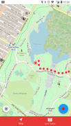
Trackbook is a bare bones app for recording your movements. Trackbook is great for hiking, vacation or workout. Once started it traces your movements on a map. The map data is provided by OpenStreetMap (OSM).
Trackbook is free software. You can find the code on GitHub (https://github.com/y20k/trackbook). GitHub is also a good place to file bugs or even to contribute, if you are interested. Trackbook is published under the MIT open source license. Trackbook uses osmdroid to display the map, which is also free software published under the Apache License.
HOW TO USE TRACKBOOK
+ Start recording movements
Press the big blue button to start recording your movements. Trackbook will continuously drop markers onto the map.
+ Stop recording movements
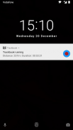
To stop your recording press the big blue button again or use the stop button in the Trackbook's notification. You can look at the recorded movements on the map afterwards.
+ Save last recording
Stop the recording and then tap again on the big blue button. It will offer an option to "Save and Clear". Trackbook stores saved recordings as plaintext JSON files in the directory /Android/data/org.y20k.trackbook/files/tracks.
+ Clear main map
Stop the recording and then tap again on the big blue button. Chose the option "Clear", if you just want to clear the map without saving your recording.
+ Statistics and Last Tracks
Peek into Trackbook's notification to see the distance and duration of your current recording. Switch to the "Last Tracks" view to review your last recordings. Trackbook stores up to 25 recent tracks. Pull up the statistics to see distance and duration of that recording, as well as the steps taken.
+ GPX Export
Saved recordings can be exported as GPX (GPS Exchange Format) from the "Last Tracks" view. Just tap the export icon next to the track selection menu.
+ How does Trackbook measure distance?
Trackbook calculates the distance between markers and adds them up.
WHICH PERMISSIONS DOES TRACKBOOK NEED?
+ Permission "INTERNET"
Trackbook needs to download map data from OpenStreetMap servers and therefore needs access to the internet.
+ Permission "ACCESS_NETWORK_STATE" and "ACCESS_WIFI_STATE"
Trackbook uses osmdroid to draw its maps. osmdroid needs to know the current state of your device’s connectivity.
+ Permission "ACCESS_COARSE_LOCATION" and "ACCESS_FINE_LOCATION"
Trackbook needs accurate GPS location data to be able to record your movements. If the GPS data is not available or not accurate enough Trackbook uses location data from cell tower and WiFi triangulation.
+ Permission "WRITE_EXTERNAL_STORAGE"
Trackbook uses osmdroid, which caches map tiles on Android's external storage. You can find the map cache in the "osmdroid" folder on the top level of the user-facing file system.
Trackbook是记录您的运动的梗概应用。 Trackbook是伟大的徒步旅行,度假或锻炼。一旦启动的痕迹,它在地图上你的动作。的地图数据是由OpenStreetMap的(OSM)提供。
Trackbook是免费软件。您可以在Github上找到(https://github.com/y20k/trackbook)的代码。 GitHub上也是提交bug,甚至作出贡献,如果你有兴趣的好去处。 Trackbook是根据麻省理工学院的开放源码许可证发布。 Trackbook使用osmdroid以显示地图,这也是Apache许可证下发布的免费软件。
如何使用TRACKBOOK
+开始记录运动
按大的蓝色按钮开始录制你的动作。 Trackbook将不断下降标记到地图上。
+停止录制动作
若要停止录制按下蓝色的大按钮,或在Trackbook的通知使用的停止按钮。你可以看一下地图上的记录运动之后。
+保存最后记录
停止拍摄,然后在蓝色的大按钮,再次点击。这将提供一个选项,以“保存并清除”。 Trackbook商店保存录音为目录中的/Android/data/org.y20k.trackbook/files/tracks明文JSON文件。
+清除主图
停止拍摄,然后在蓝色的大按钮,再次点击。这一选择“清除”,如果你只是想清除地图而不保存记录。
+统计和最后一个曲目
窥视到Trackbook的通知即可查看当前录音的距离和持续时间。切换到“最后的曲目”视图查看您的最后录音。 Trackbook存储多达近25个轨道。拉起的统计数据看到,记录的距离和持续时间,以及所采取的步骤。
+ GPX出口
保存录音可以从“最后的曲目”视图中导出为GPX(GPS交换格式)。只需轻按旁边的曲目选择菜单中的导出图标。
+如何Trackbook测量距离?
Trackbook计算标记之间的距离,并增加了起来。
某些权限TRACKBOOK需要什么?
+许可“互联网”
Trackbook需要下载从OpenStreetMap的服务器的地图数据,因此需要接入互联网。
+许可“许可权”和“ACCESS_WIFI_STATE”
Trackbook使用osmdroid绘制其地图。 osmdroid需要知道你的设备的连接的当前状态。
+许可 “ACCESS_COARSE_LOCATION” 和 “ACCESS_FINE_LOCATION”
Trackbook需要精确的GPS定位数据,能够记录你的动作。如果GPS数据不可用或不够准确Trackbook从手机信号塔和WiFi三角测量使用位置数据。
+许可 “WRITE_EXTERNAL_STORAGE”
Trackbook使用osmdroid,这对Android的外部存储缓存地图图块。你可以找到面向用户的文件系统的顶层,在“osmdroid”文件夹中的地图缓存。


